Sign up FREE
and access up to 7 premium artworks!
- $0 forever
- upgrade anytime
Buy premium account
for unlimited access and artist support!
- access to all premium artworks
- all-in-one zip packs
- one time payment, does not renew
Buy merchandise with my artwork:


Vlad Gerasimov
17 July 2009
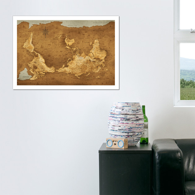
I stumbled upon this kind of map in souvenir shop in New Zealand. I immediately fell in love with this idea! Because I love maps; and I love when things suddenly go upside down; and I love when familiar things get unexpected look! This artwork is designed with large printing in mind - it will look perfect as large poster! On smaller screens, all details might look too little though. I hope you will enjoy it! As always, created in Photoshop, with Wacom. Work duration: 12 hours precisely (non-stop :-).
Martin Stružský
17 July 2009
Great idea, and I'm really pleased that I was the first one to know about this wallpaper from you. :-) Thanks!
Philippe
17 July 2009
Waow! Excellent idea, and very nice work.
Did you make the map? I love the way the coasts are "rounded"
Vlad Gerasimov
17 July 2009
Philippe: yes I made the map indeed :-) I took real world map, flipped it and used for reference. I outlines continents, then added colors, shadows, textures, then added all texts, then little objects.
Missmath
17 July 2009
Здравствуйте Влад,
I was looking for such a map for quite a while, so thank you. Now that I see how you did, I don't know if I should dare a special request... it would ba a map rotated by 90°. Meridians would be parallels. I'm pretty sure nobody ever tried that ;-)
Спасибо for your great work.
Oomu
17 July 2009
I miss corsica... south of... hu I mean North of France.
Mario Fern
17 July 2009
I hate that dotted lines! Make a version without them :(
Imagine Programming
17 July 2009
Nice design, I like it that it's flipped over. I noticed the Netherlands on there too (Neth) well done! hehe.
Luke Sky Walker
17 July 2009
Hi Vlad! I am a Kartograph. Where is Italy and Greece? Danemark is less smaller. But nice design. Next: Pegasus Galaxie??
Jo
17 July 2009
Upside down - bah!!! I live in NZ - finally you have a map the correct way up!!!
Hai Binh Nguyen
17 July 2009
you misspelt "VIET NAM" as "VITENAM"
Morgan
17 July 2009
Ah the world right way up for once and Pacific-centric as it should be! :D
Fede
17 July 2009
The original idea was from Joaquín Torres García in «América invertida» (1943).
More info → http://en.wikipedia.org/wiki/Torres_Garcia
Vlad Gerasimov
18 July 2009
Jo: good point! Hai Binh Nguyen: I knew I must make mistake somewhere! I'll fix it and upload new version. Fede: Thanks for the link, did not know that!
Matthew Long
18 July 2009
Well done Vlad. It's really nice
Geoff Gilbert
18 July 2009
Brilliant, but I see you believe that global warming will melt the Arctic soon?
Jeremy Kemp
18 July 2009
I saw that map just a couple of weeks ago. I love it!
Ellen Olenska
18 July 2009
Great idea, and good job, but Hungary is strange... And I miss Croatia!
Kris
18 July 2009
I follow your work for quite some time. I can say I am a fan of your art. I love maps and I collect maps too, but this one... I don't know. I think it is a miss.. poor color choice, no debt in the expression... The 180-degree rotation is a good idea, but it is not enough.. something is missing. Hard to explain -maybe not possible at all- but I think you can do better than that. No offense, it is intended just a friendly advice.
JudiKaye
18 July 2009
YIKES!! Vlad... This perspective is making me dizzy! I feel my world spinning...
But it's FUN, like a carnival ride. :) Keep up your fine work. I enjoy it very much.
Νίκος
18 July 2009
Wow, Russia looks BIG. Never realized it had a greater area than the European continent until now. (Actually it looks big on this map because of the projection: it's close to the pole.)
Martin Trojan
19 July 2009
Slovak Republic gone again...
Ard1
19 July 2009
hi dear vlad, nice design,
Jan Blazicek
19 July 2009
Totally...unable...to orient :D... Great piece of work.
destiny
19 July 2009
you missed serbia... and you have a lot of fans here...
19 July 2009
he will add serbia, because we do belong to this upside down world :-)
Minh Hieu TRINH
20 July 2009
Nice work and nice idea like always !!
Sprogz
20 July 2009
Nice work Vlad, you are one talented dude.
You mentioned that you took a real World map and outlined the continents. Did you have this real World map on another monitor, look, then copy, look, then copy or some sort of onion-skin layer and traced over it?
Did you draw the continents using the Photoshop pen tool or literally just a painbrush to block them out?
I'm just interested in your method.
I'd love to see a tutorial on how you create one of your masterpieces one day? Please.
hat
20 July 2009
oh god nooo!!!!!!!!!!!!!!!!!!! where is slovakia??? someone forgot that czechoslovakia is divided for 16 years... so sad
25 July 2009
GAJA BOOOOuuuwwwwzzzzzzzzz!!!!!
Alberto De Armas
27 July 2009
ok, ok, ok... That's IT! you see that small island in front of Dominican Republic???? That's my birth place: PUERTO RICO. and FYI it is part of USA. Please fix that and we are all gonna be happy.
Daniel Larsen
30 July 2009
It's not often you find something this simple yet creative. Great, great work!
Stefan Monov
12 August 2009
This is without a doubt your most astounding work. Better than They Stole the Moon. I am speechless.
Dave
13 August 2009
I had my globe at home turned this way. People always say it's upside down, but I always ask how do they know. An alien space ship cold come flying in with the South pole up and that would be thier first impression of the earth. They would say all our maps and globes are upside down.
siddhesh
19 August 2009
very good art
sahari
28 August 2009
nice !!!
sahariii
28 August 2009
hi vlad !! good Design !! :D
Katie
24 September 2009
For New Zealand, you have labelled one island as 'Steward Island'...it's actually 'Stewart' Island. As a Kiwi, I think it's great to see a map finally the right way up!
Though perhaps the colours should be a bit different...the map is a bit overwhelming and complicated.
Keep up the good work!
Evgeny from Novosibirsk
28 September 2009
Vlad, great work and astonising design! I was even more surprised to know you are from Irkutsk. Best of luck. you are great.
MA
20 October 2009
Funny way to look at things.... XD
Dragon
22 October 2009
hi is a my map....
Chris
26 October 2009
Hey, this looks really good. I was wondering, am I the only person who would love a map in this style the "right way up"??
Ja
26 October 2009
super!
Shato
31 October 2009
Vlad,
i consider you to be a great artist and a visionary.
You've inspired my taste in everything and anything that concerns graphical forms around me.
but please, PLEASE don't forget to draw Slovak Republic on your maps!
..it makes me feel like I'm forgotten... :-(
Juraj
3 January 2010
good website
Robert dot studio
21 January 2010
This is fantastic! When i get some more cash I'll register to support your work!
Thanks!
阳阳-中国
5 February 2010
我爱MAPS。
MAPS是好。
Жека
17 March 2010
Интересная карта
31 March 2010
oh so what it has dotted lines big deal there bearly noticable get a life man!
Rosie
9 April 2010
Beautiful - thank you - exactly what I was after for my desktop :) Being in Australia it's nice to not always be 'down under'. ;)
Pivo
10 May 2010
I love this image. I haven't changed my desktop since I found this over a year ago, it's beautiful.
Decibel
26 May 2012
Wow! Africa looks like an old person! Crazy! :D
Gabriel
7 June 2012
Muito criativo, parabéns!
Élisée
23 October 2012
I love it!
I can't believe it's been around for over three years and I never noticed! -_-
Hugo
7 August 2013
I love the map but noticed Israel is missing!
Tim
30 October 2014
Does the shading indicate elevation?
Dan
7 October 2018
Beautiful work. I love the idea, and I love the design!
CarenS
5 June 2025
This is my all time favorite. I have this in a skin that I purchased over 10 years ago. However, I have changed MacBooks to a MacBook Air and this is no longer available in a skin. Please make this available.